


Istar Pulsar 3d camera for GSV7682
Pages:
1
 WGAN WGANStandard Member Cayman Islands |
Harrycayman private msg quote post Address this user | |
| Hi Can anybody tell me if they purchased the istar Pulsar camera and how it is going with mapping 3d street view? |
||
| Post 1 • IP flag post | ||
 WGAN WGANStandard Member Bon Secour, Alabama |
Chemistrydoc private msg quote post Address this user | |
| @harrycayman I plan to do so, but I'm waiting until they have a marketable backpack mount and a car roof mount. And, they can't give me any clue as to when that will be. |
||
| Post 2 • IP flag post | ||

Frisco, Texas |
Metroplex360 private msg quote post Address this user | |
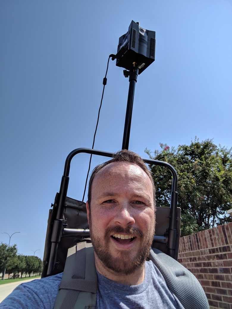 We're proudly using the NCTech iStar Pulsar! Here's the scoop: - It's 2x the resolution of the insta360 Pro 1 and Pro 2 for GSV. It's far more crisp. - Out of the box, it has connectivity issues that are frustrating but are resolved with a firmware update. - Presently, as it was presumably tested in Ireland, all imagery is overexposed. We're waiting on a firmware update that will increase the shutter speeds appropriately. - The 'VR.World' system (which is like my.matterport.com in essence) is still rather rudimentary, but it does the job that it is supposed to do in showing uploads and allowing a preview before publishing to GSV. - We have discovered that when we upload imagery -- even if it is not level, Google seems to automatically level it shortly after it is posted. Therefore, in the picture about, I'm wandering around with a DIY Trekker (link) without a gimbal -- just a lightstand with a camera -- and the end result is leveled content. Here's some test content: https://goo.gl/maps/TrYGNWvNJ7u When this first appeared on Google, it was NOT level. It is VERY overexposed. We will be removing this in a week or so. The deletion option is available via the Street View App. |
||
| Post 3 • IP flag post | ||

|
TakedaSan private msg quote post Address this user | |
| Hi Chris @Metroplex360, Have you tried to make a tour inside any company with this camera? If you do so, can you share with us please? I enjoyed the DIY Trekker you made. And the images have a great quality, I think the only problem is the overexposure as you said. Nice job. Congratulations! Jefferson Takeda |
||
| Post 4 • IP flag post | ||
 WGAN Forum WGAN ForumFounder & WGAN-TV Podcast Host Atlanta, Georgia |
DanSmigrod private msg quote post Address this user | |
| @Metroplex360 Cool! Thanks for sharing the GSV example too. Can you easily remove – or replace – the NCTech logo - if you want? Dan |
||
| Post 5 • IP flag post | ||
|
Frisco, Texas |
Metroplex360 private msg quote post Address this user | |
| @TakedaSan So far, no. We are very optimistic about using the Pulsar to traverse areas such as indoor malls as they usually have skylights, which I imagine would allow for GPS to work accurately (especially on the top level). As 'Street View Ready Pro Grade' devices rely heavily on accurate GPS, and GPS is often extremely difficult to obtain accurately within structures, I'm not optimistic about the use for walking a business and using the device as a substitute for normal GSV capture. That doesn't mean I won't be trying it Google does not seem to be imposing too many restrictions on content at the current time. I was delighted to see how Google automatically levels the submitted imagery and imagine that at the same time that it calculates the appropriate pitch/roll, that it also applies some Machine Learning algorithms to understand the captured content. I would not be surprised if imagery submitted from these devices that was inside of a small store would be rejected as it would be detected that one was attempting to create a road inside of a shop. -- @DanSmigrod - We are supposed to be able to change our Nadir. At the moment, the 'VR.World' concept is pretty rudimentary. I almost feel like I work for NCTech as a technician rather than a customer I believe that the NADIR patch should be a function of the app, although I am not seeing the option at the current time. |
||
| Post 6 • IP flag post | ||
|
WGAN Forum Founder & WGAN-TV Podcast Host Atlanta, Georgia |
DanSmigrod private msg quote post Address this user | |
| @Metroplex360 In the mean time, I could imagine that you could use a GSV moderator - such as Panoskin Pro or GoThru - to import the GSV tour; swap-out the nadir patch and repost to GSV? Best, Dan |
||
| Post 7 • IP flag post | ||
|
WGAN Standard Member Cayman Islands |
Harrycayman private msg quote post Address this user | |
| Hi Chris Ok so you are doing GSV and uploading. Who is paying for this service? Are you doing street view and then selling businesses along the way? Just trying to figure out after camera purchase then the uploading charges to NCTech how money is made. Can you shed some light on that. |
||
| Post 8 • IP flag post | ||
Pages:
1This topic is archived. Start new topic?