


Using MP to scan SR-71 in museum2677
Pages:
1

|
DSPhoto private msg quote post Address this user | |
| Looking for a way to do a model of a museum with an SR-71 Blackbird suspended from the ceiling. It would be ideal to make this more of a VR headset presentation. Or a free floating camera type thing I've seen in First Person Shooter games. Any ideas? Unity maybe? Thanks |
||
| Post 1 • IP flag post | ||

|
PieroBortolot private msg quote post Address this user | |
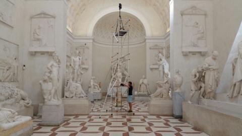 Scaffolding It's like to fly |
||
| Post 2 • IP flag post | ||
|
|
DSPhoto private msg quote post Address this user | |
| Thanks PieroBortolot. I figured it would be a rig like that but I'm more concerned about the rendering of the model. How does the viewer navigate. For example I'd like to for the viewer to be able to fly or float around and be able to look at any part of the plane from tip to tail. Do you have an example of the model you made from above? Thanks |
||
| Post 3 • IP flag post | ||
|
|
PieroBortolot private msg quote post Address this user | |
| Sorry, I can't share the model | ||
| Post 4 • IP flag post | ||
 Tosolini TosoliniProductions Bellevue, Washington |
Tosolini private msg quote post Address this user | |
| I scanned a b-29 recently and I had similar issues. We tried to navigate up and down and positioned the camera at different heights. Here is what the experience looks like when you move: https://my.matterport.com/show/?m=Qa3Lu8iPfHW&start=1,2f214464a6d44e449fcee45621b9c9b0,0.3280,-1.1666,0.3251,0.0070,0.0543,-0.0004,0.9985 |
||
| Post 5 • IP flag post | ||
|
|
DSPhoto private msg quote post Address this user | |
| Thanks Tosolini, Flying over Europe in those things had to be just terrifying! This is a little different. It is a big wing of a museum with an actual SR-71 suspended from the ceiling. So I'm shooting this big room with a plane in it and want to be able to view the plane from tip to tail. Can I do multi-level scans giving me view points from 6, 12, 18, & 24 feet high but have the model be just one level? Thanks |
||
| Post 6 • IP flag post | ||
|
Tosolini Productions Bellevue, Washington |
Tosolini private msg quote post Address this user | |
| @dsphoto I don't know the answer. I'm thinking that if you treat every height as a different floor, it might work. I really don't know though and if you could do a test on some other model beforehand, it could be safer. Did you try to engage the MP support for suggestions? Let us know what's the outcome. I'm curious. | ||
| Post 7 • IP flag post | ||
|
|
PieroBortolot private msg quote post Address this user | |
| Yes. When you do multi-level scans from the scaffolding you have a model with one level | ||
| Post 8 • IP flag post | ||
Pages:
1This topic is archived. Start new topic?