


Why do I see a GSV Blue Line in Streets App but not Google Maps?14457
Pages:
1
 WGAN Forum WGAN ForumFounder & WGAN-TV Podcast Host Atlanta, Georgia |
DanSmigrod private msg quote post Address this user | |
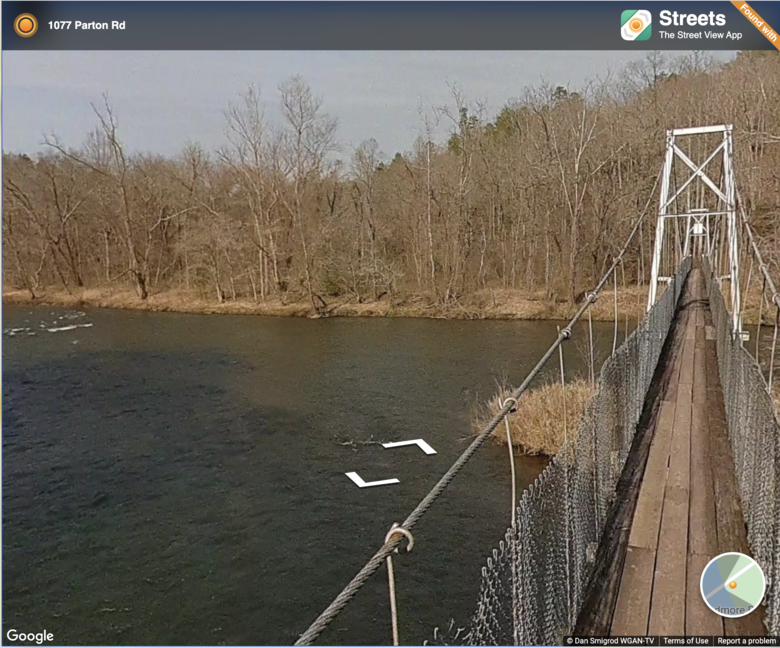 Screen Grab: Needmore Rd Suspension Bridge (capacity 4 people) in the Nantahala National Forest, Bryson City, NC Hi All, Why do I see this Google Street View Blue Line in the Streets App but not in Google Maps? (This is the Needmore Rd Suspension Bridge (capacity 4 people) in the Nantahala National Forest, Bryson City, NC) (I shot this Google Street View "Blue Line" on Wednesday, 10 March 2021 with a Labpano Pilot One EE 360 camera.) Dan P.S. Labpano loaned me the Pilot One EE to take for a spin ... ✓ Labpano Pilot One EE (Adorama Store) ✓ Labpano Pilot One EE (Labpano Store) |
||
| Post 1 • IP flag post | ||
 WGAN Fan WGAN FanClub Member Queensland, Australia |
Wingman private msg quote post Address this user | |
| Because in its default state Google Maps are loading in a plain map mode. There are Android/apple apps that can load google maps in street view mode where it shows all blue lines and even 360 photo spots. Another way to see blue lines is to grab that yellow pegman figure located at the bottom right corner on maps.google.com If you grab it(right click with a mouse and hold it) and bring it over the map it will switch to blue lines mode. if you drop it(release a mouse button) on any blue line or on any circle representing somebody's 360 it will show a 360 view and also shows a map with blue lines in a small window. This map window can be expanded so you can have half of the screen with a 360 view and another help with the map with all blue lines shown. This all though works on windows pc and laptops only and I don't even think you will be shown a pegman even on Android tablet/phone. For some reason goggle kind of restricting maps functionality on Android. The same will happen to IOS(iphone/Ipad) even with native Google Maps app installed. However as I mentioned there are apps that can show street view and all blue lines. I think the one for Apple is called StreetViewMap without spaces between each word. You can also see your own blue lines in Street View app by Google that is used to capture 360 tours and submitting them to Google. If you want to see yours go to Profile, select those that have been processed and live and it will open a map exactly where it has been captured and it will draw a blue line for the whole length it covers. |
||
| Post 2 • IP flag post | ||
|
WGAN Fan Club Member Queensland, Australia |
Wingman private msg quote post Address this user | |
| Sorry I have probably written much more than needed to answer your question and still have not answered it :-) I can see it on maps.google.com Here is a link to the line https://goo.gl/maps/1RdCDt1m5FJi8Wbi9 and a screenshot with the blue line shown is below 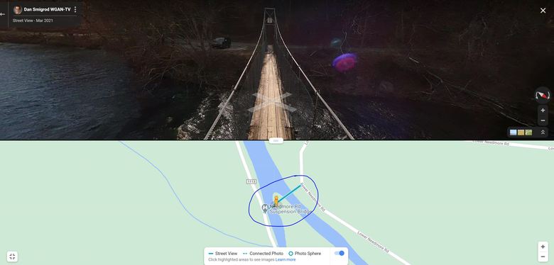 |
||
| Post 3 • IP flag post | ||
|
WGAN Fan Club Member Queensland, Australia |
Wingman private msg quote post Address this user | |
| BTW, there are a lot of roads around that bridge that are missing blue lines. So if you can mount a Pilot One on your car, use a bike or walk along them(make sure it is safe to do) you can actually capture and submit all of them. And do not forget about your nadir logo to cover yourself. Pilot cameras have this functionality and you can apply your logo in camera settings. |
||
| Post 4 • IP flag post | ||
|
WGAN Forum Founder & WGAN-TV Podcast Host Atlanta, Georgia |
DanSmigrod private msg quote post Address this user | |
Quote:Originally Posted by Wingman Ah! Yes! That worked! Much thanks on all the backstory. I found that very help/interesting. I went ahead and published one of my new GSV "Blue-Lines" here: ( once you reminded me about Pegman ✓ About my Labpano Pilot One EE Google Street View Meets NC Waterfalls Dan |
||
| Post 5 • IP flag post | ||
Pages:
1This topic is archived. Start new topic?