


Blue Line Street View walking captures NCTech Pulsar, GoProMax & LabPano EE13502
Pages:
1

|
SiteTour360 private msg quote post Address this user | |
| For anyone that is curious about comparing Blue Line results with NCTech iStar Pulsar, GoPro Max & LabPano EE....I recently did the walking trails of a local park (Ocala Wetland Recharge Park). All published to SV as Blue Line fine. Lighting conditions were not ideal as it was later in the day. Here are 3 links: iStar Pulsar (3 meter spacing to VR.World to GSV) - https://goo.gl/maps/5hXgHhyj7UqSn92v5 GoProMax (30 FPS video to MP4 to GoThru to GSV) - https://goo.gl/maps/fbtpXG2LdQ1u7Atg8 LabPano EE (2fps to GSV)- https://goo.gl/maps/kqbR6tzmUnxwzH9T7 By far, the easiest workflow was Labpano EE. 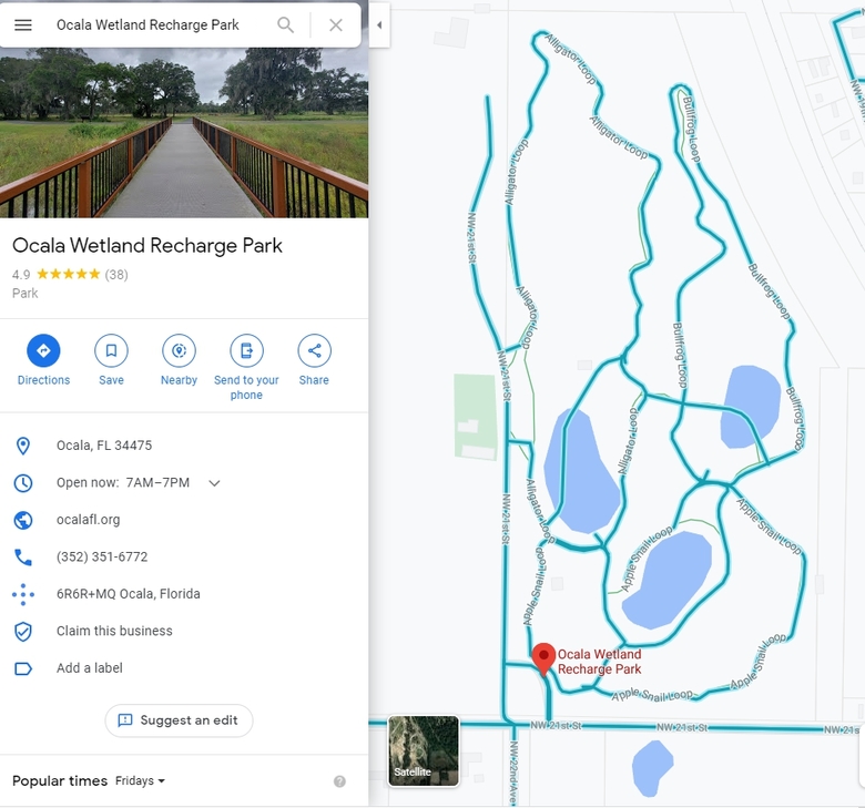 |
||
| Post 1 • IP flag post | ||
 WGAN Forum WGAN ForumFounder & WGAN-TV Podcast Host Atlanta, Georgia |
DanSmigrod private msg quote post Address this user | |
| @SiteTour360 Thank you for sharing this comparison with the WGAN Community. Leveling is much, much, much better in your Pilot One EE testing (above) than my test shot on walking paths. Is this because you your pole was straight up (looking at the shadows) and mine wasn't (and I figured that Google Street View would straighten)? Could it have anything to do with FPS? Yours was 2 FPS and mine was 6 FPS. Your paths were flat and on pavement: mine were up and down hills without pavement. Best, Dan |
||
| Post 2 • IP flag post | ||
|
|
SiteTour360 private msg quote post Address this user | |
| I never count on Google to level anything...always shoot as level as possible. Increased frame rate should not cause images to blur....got to be something else I would think. | ||
| Post 3 • IP flag post | ||
|
|
uk_man private msg quote post Address this user | |
| @SiteTour360 Have you done anymore GSV blue lines with the pilot One EE, could you post a link to them please. Thank You |
||
| Post 4 • IP flag post | ||
|
WGAN Forum Founder & WGAN-TV Podcast Host Atlanta, Georgia |
DanSmigrod private msg quote post Address this user | |
| @uk_man My first project: most problems are user error (me)! ✓ How to Create Google Street View Blue-Line Map Updates with a Pilot One EE Dan |
||
| Post 5 • IP flag post | ||
|
WGAN Forum Founder & WGAN-TV Podcast Host Atlanta, Georgia |
DanSmigrod private msg quote post Address this user | |
| Google Street View Blue Lines shot by We Get Around Atlanta Chief Photographer Dan Smigrod @uk_man I shot the "blue-lines" added to this business's parking lot (and a little bit inside) with a Pilot One (and retouched the images such as adding blue sky). I did not shoot it originally as Pilot One Google Street View video mode because the external GPS unit could not see the satellites. I now shoot with the Labpano Pilot One EE (previous post). I have not had a chance to shoot GSV again. Dan P.S. Heading out for the day. If you write back, I will likely be slow to reply. |
||
| Post 6 • IP flag post | ||
|
|
SiteTour360 private msg quote post Address this user | |
| @uk_man - I have some more...will post later today. Have only had the camera a couple of weeks but really liking it so far....easy workflow and image quality is good/passable for some uses. | ||
| Post 7 • IP flag post | ||
Pages:
1This topic is archived. Start new topic?